600,000 Without Power in Washington State as Powerful Winds Topple Trees ‘Bomb Cyclone’
A powerful storm system is currently wreaking havoc across Washington State, bringing hurricane-force winds, heavy rain, and widespread power outages that have left over 600,000 customers in the dark. This inclement weather is part of a larger atmospheric river event, a phenomenon characterized by a narrow corridor of concentrated moisture flowing in from the Pacific Ocean, poised to impact a broad swath of the Northwest Bomb Cyclone.
On Tuesday night, residents experienced wind gusts reaching up to 77 miles per hour, as reported by the National Weather Service’s Seattle office. It’s important to note that hurricane-strength winds begin at 74 mph, indicating just how severe these conditions have become. As the storm approached, drivers were urged to stay off the roads, with the National Weather Service warning that strong winds would be prevalent until approximately 4 a.m. local time. Such dangerous conditions can lead to fallen trees and downed power lines, creating additional hazards for those who venture out.
As of 11 p.m. Tuesday, the poweroutage.us website reported that around 600,000 electricity customers were without power across the state. Even the Weather Service’s Seattle office experienced an outage, disrupting its radio transmissions. The storm has not only caused power outages but is also bringing about other serious concerns, such as life-threatening flooding and large ocean waves.
In addition to the winds and rain, heavy snow is forecasted for the Cascade Mountains, which could complicate conditions further. The National Weather Service warned that the ferocious winds over the ocean might pose significant risks to vessels at sea, with potential for capsizing or damage.
Adding to the disruptions, Amtrak has announced the cancellation of several train services running between Seattle, Oakland, Portland, and Spokane, effective through Thursday.
As this powerful weather system continues its trajectory, it’s also set to affect Northern California. Forecasters predict that the Bay Area and surrounding regions will begin experiencing heavy rainfall overnight, with an expected deluge potentially dropping more than a month’s worth of precipitation in just three to four days.
As the storm develops, it serves as a stark reminder of nature’s power, urging communities to remain vigilant and prepared as they face these intense weather conditions. Stay safe and stay informed during this turbulent time.
Pacific ‘Bomb Cyclone’ Ushering In Strong Atmospheric River To West With Heavy Rain, Snow, High Winds
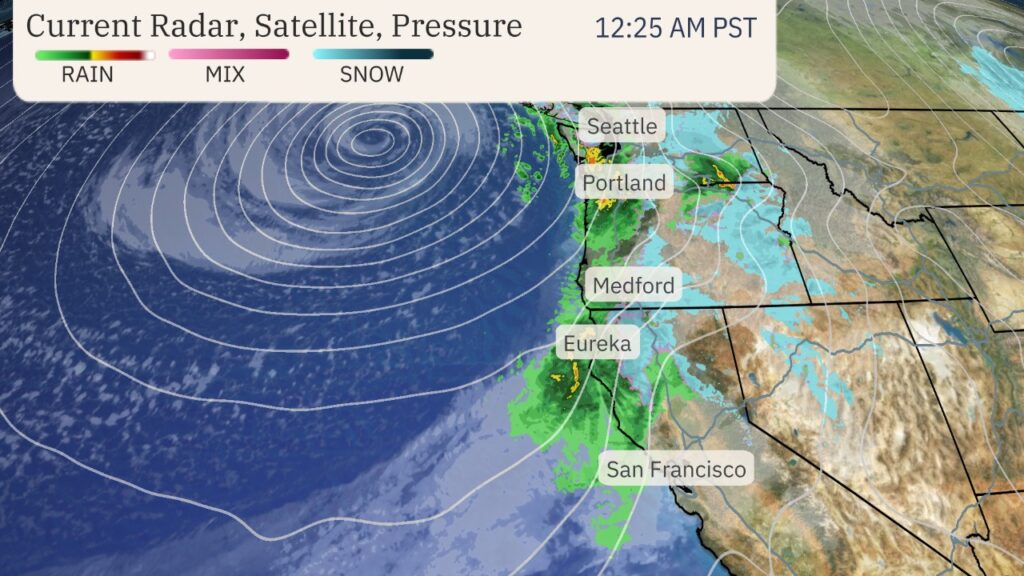
A rapidly intensifying storm system, often referred to as a “bomb cyclone,” is making its way toward the West Coast, bringing with it an atmospheric river loaded with substantial moisture. This phenomenon, known as bombogenesis, occurs when a storm’s pressure drops by 24 or more millibars within a 24-hour period. Such rapid intensification often leads to more pronounced impacts compared to weaker storms, making this weather event particularly noteworthy.
As the storm approaches, meteorologists are tracking its progress near the Northwest coast through current radar, satellite visuals, and surface pressure readings. The incoming moisture plume is set to produce significant rainfall and snowfall, particularly in Northern California and parts of Oregon, creating a potentially hazardous situation for residents in these areas.
Expected Impacts Through the Week
The peak effects of this storm system are projected to manifest through Friday, with conditions possibly lingering into the weekend for some regions. Here’s a closer look at what to expect:
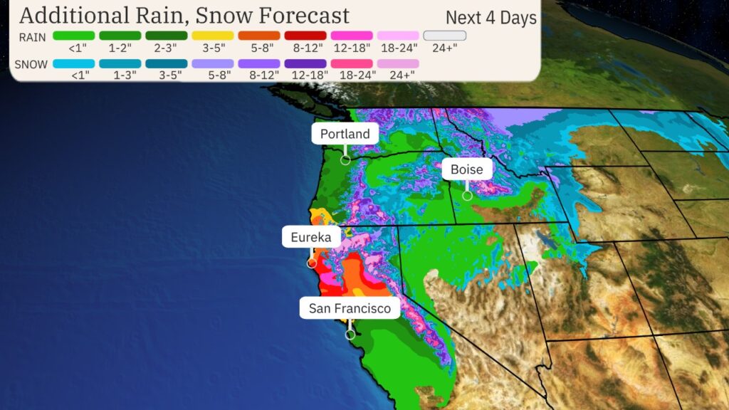
Heavy Rainfall: The most substantial rainfall totals are anticipated in Northern California, especially north of the Bay Area, extending into southwest Oregon. Some areas might receive between 8 to 12 inches of rain, with isolated regions possibly experiencing up to 15 inches. This overwhelming deluge poses serious risks to low-lying areas, with a heightened potential for flooding in poorly drained spots, along with creeks and rivers. Residents should also be aware of the increased threat of mudslides, particularly in areas affected by recent wildfires, while rock slides may occur along mountain roads.
Due to the severity of the flood threat in northwest California, including places like Eureka, the National Oceanic and Atmospheric Administration’s Weather Prediction Center has issued a rare high-risk excessive rainfall outlook for Thursday.
Snowfall: In addition to heavy rain, the storm will bring substantial snowfall to the higher elevations from the Cascades down to the Siskiyou and Sierra mountains of Northern California. Snow levels are expected to start low but will rise as the week progresses, which could complicate travel through mountain passes.
Snoqualmie Pass on Interstate 90 in Washington and Siskiyou Pass on Interstate 5 near the California-Oregon border will see significant impacts from both snowfall and strong winds.
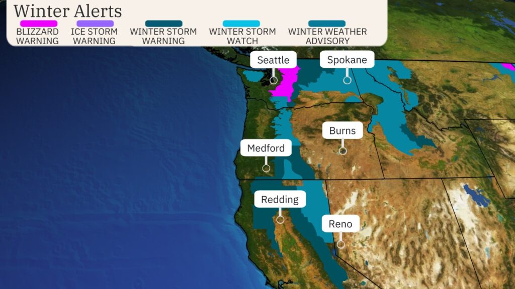
The National Weather Service has issued winter weather alerts spanning from the Cascades down to California’s northern Sierra, including a blizzard warning for the Washington Cascades from late Tuesday into early Wednesday. Travel is highly discouraged in areas under these warnings due to dangerous conditions.
As this bomb cyclone ushers in a powerful atmospheric river, residents in the affected areas should prepare for challenging weather ahead. Stay safe, stay informed, and take necessary precautions as this storm unfolds.